- Garmin GPSMAP1623 16" GPS Chart Plotter Worldwide Basemap
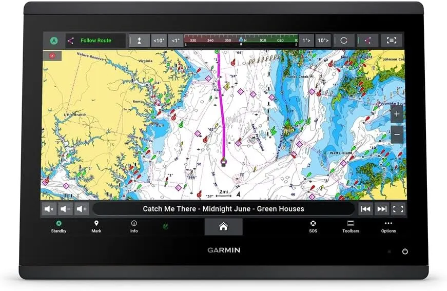
Garmin GPSMAP1623 Chartplotter with Worldwide Basemap Model: 010-02919-00 High-resolution 16" touchscreen, IPS display offers sunlight readability and visibility from any angle, even with polarized glasses Experience fast and responsive high-speed processing power of the GPSMAP® x3 series chartplotters Slim display borders and edge-to-edge glass make it easy to fit a wide range of helm configurations Support for mapping includes Garmin Navionics ™ charts with built-in Auto Guidance ™ technology and Garmin Navionics Vision ™ cartography with premium features, such as high-resolution relief shading (Auto Guidance is for planning purposes only and does not replace safe navigation operations) Get support and integration for your Force® trolling motor (sold separately) to gain complete control while you fish See engine information such as RPMs, fuel flow and more for compatible engine manufacturers Connect and control compatible third-party devices through EmpirBus™ digital switching and other OneHelm™ integrated digital switching-compatible products Easily build your marine system — from compatible sonar, autopilot, radars or cameras — by using NMEA 2000® and NMEA 0183 network connectivity and the Garmin Marine Network Use built-in Wi-Fi® technology to pair with the free ActiveCaptain® app for access to OneChart™, smart notifications, software updates and more (requires app on your compatible smartphone) Integrated ANT® technology supports connecting to your compatible quatix® marine smartwatch, gWind™ Wireless 2 transducer, GNX™ Wind marine instrument and wireless remote controls Built-in J1939 integration Embrace connectivity, clarity and control at the helm with the GPSMAP® 16x3 chartplotter. This advanced MFD supports the same
- Product Dimensions : 20 x 20 x 20 inches; 15 Pounds
- Date First Available : February 14, 2024
- Manufacturer : GARMIN
, Soothing & Moisturizing Face Wash for Dry & Sensitive Skin, Paraben-Free, Soap-Free, Sulfate-Free, 6.3 oz (Pack of 2)")


")


 Ultra High Capacity, Replacement for iSpan BTA002 Battery")
