- Printed on Tyvek® (synthetic)
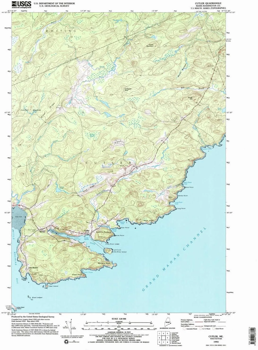
- USGS topographic map of Cutler, ME, at 1:24000 scale. Lighter material. Waterproof. Tear-resistant. Foldable. Very durable. Perfect for backpacking and the outdoors.
- Cities, towns, villages: Cutler,Little Machias
- Mountains: Eastern Knubble,Cocoa Mountain,Compass Rock,Stone Hill
- Valleys: Low elevation topographic features such as flatlands, river valleys, and canyons.
USGS topographic map of Cutler, Maine, dated 1993, updated 1995.
Includes geographic coordinates (latitude and longitude), lines of elevation, bodies of water, roads, and more. This topo quad is suitable for recreational, outdoor uses, office applications, or wall map framing.
Printed on-demand by YellowMaps on the print material of your choice.
Shipping rolled from Minneapolis, MN, United States.
Product Number: USGS-5533503
Map Size: 26.9 inches high x 21.5 inches wide
Map Scale: 1:24000
Map Type: POD USGS Topographic Map
Map Series: HTMC
Map Version: Historical
Cell ID: 11115
Scan ID: 105061
Imprint Year: 1995
Woodland Tint: Yes
Aerial Photo Year: 1993
Edit Year: 1995
Field Check Year: 1993
Datum: NAD83
Map Projection: Universal Transverse Mercator
Map published by United States Geological Survey
Map Language: English
Scanner Resolution: 600 dpi
Map Cell Name: Cutler
Grid size: 7.5 X 7.5 Minute
Date on map: 1993
Geographical region: Maine, United States
Northern map edge Latitude: 44.75°
Southern map edge Latitude: 44.625°
Western map edge Longitude: -67.25°
Eastern map edge Longitude: -67.125°
Surrounding map sheets (copy & paste the Product No. in the search bar):
North: USGS-5637963,USGS-5637949,USGS-5684177,USGS-5637957,USGS-5637959
East: USGS-5534565,USGS-5534567,USGS-5534569
South: USGS-5534781
West: USGS-5534375,USGS-5534373,USGS-5534371,USGS-5684599,USGS-5534369
")


 Driving Safety Video Training Kit - COMPREHENSIVE training for UNLIMITED employees with video, quizes, certificates and more!")


![2-Pack Anti Blue Light Screen Protector, compatible with QNIX QX2710 LED Evolution II DPmulti True10 LED Multi True10 27" Monitor TPU Film Protectors Sticker [ Not Tempered Glass ]](https://www.emgcompact.shop/image/2-pack-anti-blue-light-screen-protector-compatible-with-qnix-qx2710-led-evolution-ii-dpmulti-true10-led-multi-true10-27quot-monitor-tpu-film-protectors-sticker-not-tempered-glass-_F2Lt9y_300x.webp "2-Pack Anti Blue Light Screen Protector, compatible with QNIX QX2710 LED Evolution II DPmulti True10 LED Multi True10 27\" Monitor TPU Film Protectors Sticker [ Not Tempered Glass ]")

